What lack of vision and sustainable planning can do to a city
August 08, 2025
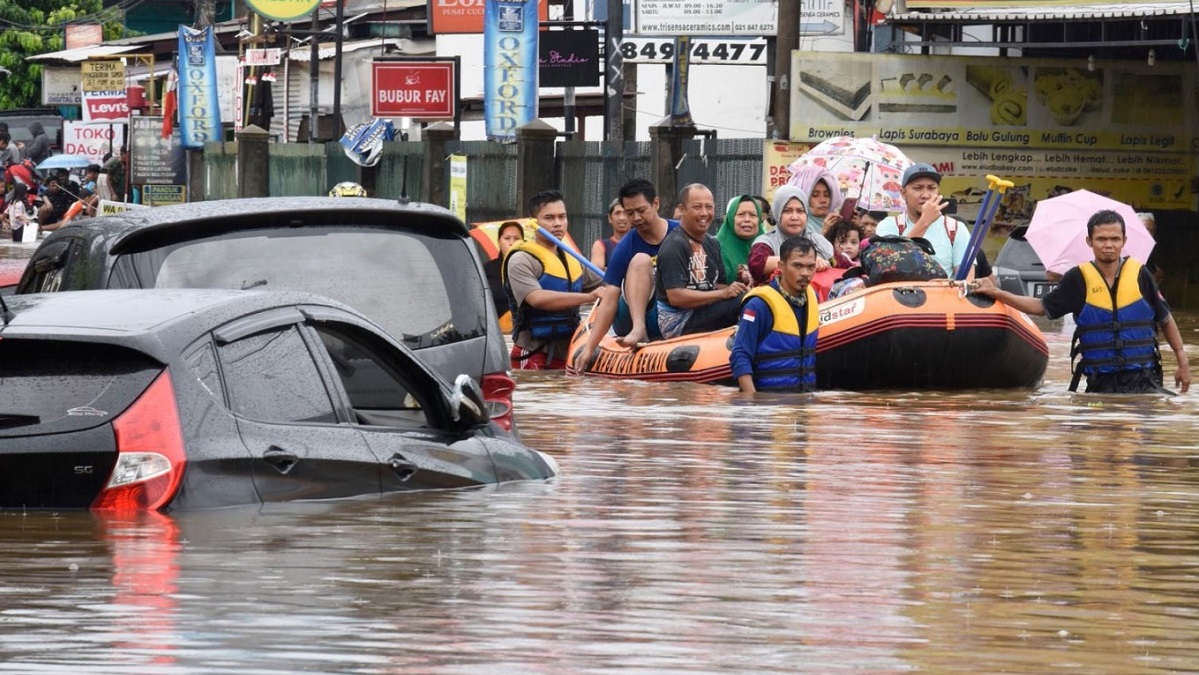
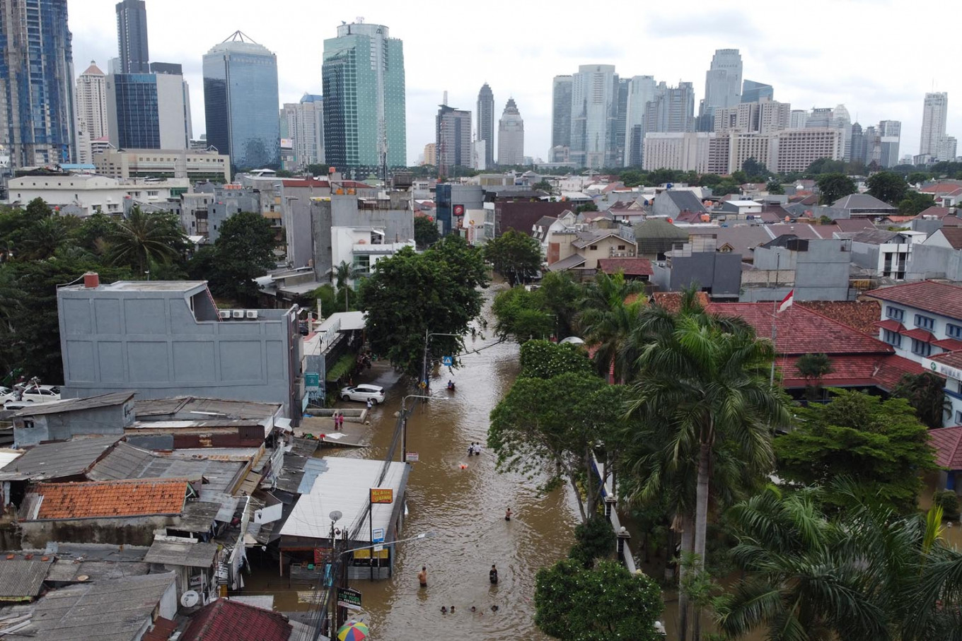
On a regular rainy day in North Jakarta, commuters have to wade through waist-deep water on their way to work. Buildings tilt, roads crack open, and entire neighborhoods disappear beneath the water line.
Land subsidence in Jakarta city is so severe that, in some areas, concrete poles once marking the ground surface now stand just head-high above the streets.
Tidal floods now reach into the city with increasing frequency, often twice a day. Public transportation is frequently halted. Even the insurance companies usually refuse to cover properties located in high-risk zones.
Jakarta is sinking at a rate faster than any other city in the world. The city subsides by 1-15 cm per year. Not only is sea level rising, but the city itself is subsiding at an alarming rate.
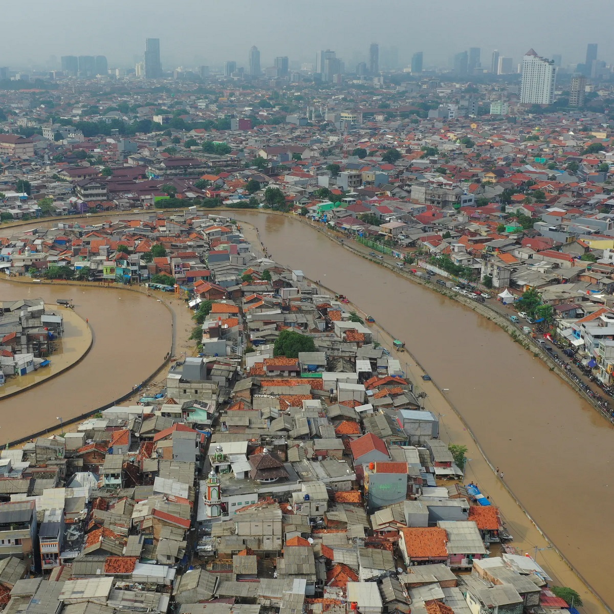
About half of Jakarta already lies below sea level. Some locations in North Jakarta have reportedly sunk by 4.1 meters from 1974 to 2010. Estimates suggest that 95% of North Jakarta will be underwater by 2050.
Why does a city sink?
At the heart of Jakarta’s subsidence crisis lies the overexploitation of underground water resources. This reliance on groundwater isn’t a contemporary phenomenon in Jakarta. Instead, it has deep colonial roots.
Formerly known as a small port town by the Java Sea, Jakarta was rebuilt as the Asian headquarters of the Dutch East India Company in 1619. The Dutch changed the name of the city to ‘Batavia’.
By 1659, Batavia had become a port city modeled after Amsterdam, complete with canals and Dutch-style urban grids. Yet, unlike its European twin, Batavia lacked an inclusive piped water system. Only selected parts of the city, particularly those inhabited by Dutch administrators and traders, had access to piped water.
In 1659, only about 12% of the city’s population had access to a centralized piped water system. The rest of the population, mostly indigenous Indonesian people, relied on groundwater.
The system was designed to serve only the Dutch elite and their economic activities.
After Indonesia’s independence in 1945, Jakarta’s urban planners inherited a fractured infrastructure that had deteriorated significantly over decades of rapid urbanization and population growth.
By 2016, approximately 40% of Jakarta’s residents had access to piped water. But this rise is far from sufficient in a city of over 10 million. The remaining 60% of residents in Jakarta rely on privately dug wells.
Groundwater extraction reached 180 million cubic meters per year by 1990, and it has continued to increase ever since. This extraction has depleted the aquifers (natural water reservoirs) beneath the city, causing the earth above to consolidate and collapse.
The more the aquifers deplete, the more the city sinks. The rapid urban development in the city restricts rain from naturally replenishing the aquifers. Since most of the city is now covered in concrete, rainwater can barely seep into the ground.
Neighbourhoods of North Jakarta are now up to four meters below sea level, exposed to both sea level rise and land subsidence.
This dual threat turns even the modest tides into floods. Sea levels around Jakarta are projected to rise by up to 90 cm by the end of the century, rendering most of the city uninhabitable.
The weight of modernity
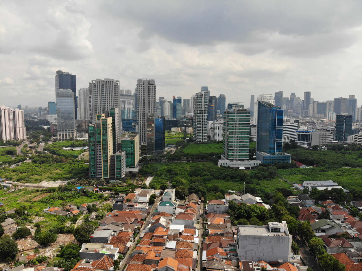
Jakarta’s skyscrapers now pose another burden on the land. The alarmingly increasing number of skyscrapers adds immense pressure on the already subsiding land.
Again, the roots can be traced to colonial planning principles. Batavia was planned in a way that almost all administrative and commercial establishments were located within specific areas, such as Kota Tua or Old Batavia in North Jakarta.
The Dutch emphasis on spatial segregation and centralization has led to an over-concentration of infrastructure, services, and economic activity in a select few areas of Jakarta. These areas are now overbuilt, overburdened, and more vulnerable to subsidence.
…to save Jakarta
The Indonesian government has come up with ambitious plans. One such effort is the construction of the ‘Giant Sea Wall,’ a $40 billion project to shield the city from the surrounding Java Sea. The wall, shaped like Indonesia’s national symbol, ‘Garuda’, aims to protect Jakarta’s coastline.
Jakarta is also attempting to reduce its dependency on groundwater by expanding piped water access and improving the city’s water network.
Rainwater harvesting and water recycling initiatives are being promoted. In 2019, the government announced plans to relocate the national capital to East Kalimantan on the island of Borneo.
Lessons from Tokyo
Tokyo, the capital of Japan, experienced significant land subsidence starting from the 1900s and accelerating after 1945. Tokyo experienced a yearly subsidence of 24 cm in the 1960s.
The major driving factor behind Tokyo’s subsidence was groundwater exploitation. Tokyo authorities soon took practical steps to reduce groundwater extraction.
Industrial Water Law (1956) and Building Water Law (1962) were soon enacted to restrict the extraction of groundwater by households and businesses.
Tokyo eventually led the industries to stop using groundwater. From 1964, the city authorities began providing industries with alternative water sources, such as rivers. Rainwater harvesting and recycling were also used.
Towards a sustainable city
Jakarta must leave behind the legacy of Dutch colonial planning principles, which prioritized elite access, centralization, and the mimicry of European cities over local needs and contexts.
A decolonized water system would prioritize universal access and facilitate a decline in groundwater extraction.
Equitable urban planning must distribute the weight and pressure of development more evenly, preventing the dangerous concentration of high-rise buildings, shopping malls, and industries in low-lying zones.
Subsidence crisis in Dhaka city
Rapid urbanization, skyrocketed demand for water due to population boom, and ad hoc development planning have continuously risked the sustainability of groundwater resources and equitable access to water in Dhaka.
For underground water, Dhaka relies primarily on the Dupi Tila Aquifer, a prominent natural water reservoir located beneath its land. The first borehole in Bangladesh to extract groundwater from the Dupi Tila aquifer was drilled in 1949.
By the 1960s, only one-fourth of the total water demand was being met by surface water sources. For the rest, Dhaka solely relied on the aquifers.
The scenario has worsened over the decades. As the city and its population continue to grow, the aquifers become increasingly depleted.
The consequences are increased flood risks, frequent waterlogging, and uneven ground sinking. Additionally, water is becoming more difficult and more expensive to access, especially for the poorer and marginalized communities.
With the booming population of Dhaka, there are now nearly thousands of boreholes that Dhaka WASA uses to extract groundwater. About 80% of the water supplied by Dhaka WASA comes from the aquifers through these boreholes.
Dhaka now extracts over a billion cubic meters of groundwater per year. Far surpassing the natural recharge rate, this overexploitation of aquifers results in a dramatic decline of 2–3 meters per year. Dhaka has seen a cumulative drop of over 75 meters in its groundwater level since the 1970s.
This overextraction is causing the city to subside at an average rate of 13–14 millimeters per year. Over the last two decades, Mirpur and Uttara experienced land subsidence by over 221 mm and 232 mm, respectively.
Ending the overexploitation of groundwater resources is essential to halt land subsidence. Dhaka has four surface water treatment plants that meet about 22% of the city’s water demand.
Under the Dhaka Environmentally Sustainable Water Supply Project (DESWSP), a new plant is under construction in Gandharbpur, Narayanganj.
Extracting raw water from the river Meghna, this plant will meet the demand of 500 million litres of water per day. It is expected to reduce groundwater pumping in Dhaka by half.
Covered with concrete and bituminous surface, Dhaka barely allows rainwater to enter the earth and replenish the aquifers beneath. Therefore, the natural rate of recharge for the aquifers is quite negligible.
Artificial recharge methods, such as rainwater harvesting and injection wells, have been explored. With artificial aquifer recharge, water gets added to the aquifers by being spread on the surface or injected through wells.
Areas including Mirpur, Uttara, Badda, Pallabi, Mohammadpur, and Demra have been identified as potential recharge sites for the aquifers.
If not given enough importance, this issue can soon reach the point of no return, and Dhaka can become the next Jakarta.
Most Read


Electronic Health Records: Journey towards health 2.0

Making an investment-friendly Bangladesh
Understanding the model for success for economic zones

Bangladesh facing a strategic test

Bangladesh’s case for metallurgical expansion
How a quiet sector moves nations

A raw material heaven missing the export train

Automation can transform Bangladesh’s health sector

A call for a new age of AI and computing
You May Also Like